The Brisbane GeoRabble crew are super excited to welcome our first two speakers to the upcoming event in March:
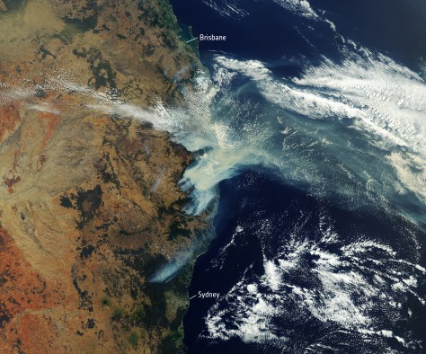
Peter Timmers – speaking on the work of the Queensland Emergency Services team and the GIS team in response to recent bush fire events
Len Olycott – presenting on the work that Queensland Department of Parks and Wildlife have been doing in collaboration with the Emergency Services
Stay tuned for another announcement soon of possible speakers from The Ripper Rescue Alliance, WIRES and iRecover platform….but in the meantime, scuttle over this way to register for the event on 11th March 2020 @ the Charming Squire; tickets are moving quick!
We are still looking for a sponsor for this event – if you’d like to help out please reach out via email or twitter. We’d love to hear from you!
The Brisbane GeoRabble crew are excited to announce that registrations are now open for the next ‘Rabble on 11th March 2020 – head over this way to register.
We are still looking for speakers and sponsors – if you have a story, tool, data or anything to share with the spatial community about disaster response, recovery & resilience we’d love to hear from you.
The team is also considering whether to run this as fundraising event – what are your (the community!) thoughts? Hit us up on twitter or email us here.
Only a couple of sleeps until the last Brisbane GeoRabble of the year and we we’re excited to announce two more fabulous speakers – Angela Marsh & Andrew Clark!
Head over this way to register (it’s free!) if you haven’t already!
GeoRabble returns to Brisbane for one last hurrah before the decade of the 20-teens is out!
Come celebrate with us as we leave the tumultuous teens and (hopefully) mature into our geospatial 2020s (possibly aligned to GDA, but lets not go there just yet).
We’re are putting out the call for speakers, so if you have a bugbear <idea>, story, discovery, topic, musing or the funniest collection of spatial memes to grace the internet – we’d love to hear from you!
And we also need an audience! Head over this way to register if you’d like to come along and join us for all sorts of geo-goodness.
EVENT DETAILS
Date: 21st August 2019
Time: Doors open at 5:30pm, the ‘rabblin starts at 6pm.
Location: Universal Bar, 221 William St, Northbridge 6003
Format: Mixed bag of spatial goodness
Registration: Attendance is free, but for catering purposes we need you to register!
Follow @georabble on twitter or use the hashtag #georabbleper to join the conversation.
We can’t hold these events without the help of the greater Geocommunity! Please contact us if you’d like to be a part of sponsoring a future event or get involved in helping organise an event.
This event brought to you by the Perth GeoRabble team and sponsored by Georabble friends NGIS.
Perth ‘rabblers kicked off the first GeoRabble of 2019 in style, with one of the biggest turnouts we’ve had in a long long time.
MC’d by the ever talented Damian Shepherd, who helped keep our speakers (and audience!) in check.
The evening started off with Ben Jones on ‘Cartography for the Colour Blind’. Colourblindness affects about 1 in 12 men and 1 in 200 women; a statistic was was represented within our own audience that night. Maps as a fundamentally visual tool rely critically on colour & shapes to communicate information. Ben talked us through some useful methods and tools to assist in selecting colouring schemes that help make reading maps inclusive and accessible to colour-reading abilities. His key tips were to spend time experimenting with palettes & textures (through use of tools such as colour brewer2 & kuler) and then to test your selections with emulators such as Colour Oracle or Visolve.
GeoRabble Perth – Ben Jones talking on cartography & colourblindness
Next up we had Sarah James speaking on ‘Convergence of Industry 4.0, Smart Cities & Spatial’.
Industry 4.0 refers to latest wave of ‘industrial revolution’, where digital networks form a vast array of networks of cyber-physical systems (connected assets, customers and supply chains). Location intelligence plays a key part in this – and is the ‘golden thread’ – particularly in the context of ‘smart cities’, digital twins, BIM & virtual/augmented reality systems.
Perth GeoRabble – Sarah James speaking on Industry 4.0, Convergence and Spatial
Following on we had John Bryant speak about his journey in organising the first Oceania FOSS4G in Melbourne last year, and on building open geospatial community in the regions. Through collaborative efforts and shared vision with people met through other channels (Slack/user groups/mailing lists etc) a team of passionate individuals pulled together an amazing conference with keynote speakers, 45 presentations & 14 lightening talks, 14 workshops, a community day & social events. An incredible 250+ attendees from 14 countries attended. And not only that, but the community succeeded in raising enough money through Good Mojo crowdfunding campaign to enable 6 people to attend through the Travel Grant Program.
Perth GeoRabble – John Bryant speaking on FOSS4G Oceania
Up next, with the title to steal the night, we had Cameron McArtney talking on ‘Making GIS accessible for a generation that searches for ‘Google’ in Google to get to Google’. An inspiring talk on the technological challenges of making digital maps for those in our community who are not of the ‘Google generation’. The choice of visualisation and interaction technique (‘scroll’/’flick’ etc) is just as key as the mapping itself to make spatial data accessible and insightful.
Perth GeoRabble – Cameron McArtney on making mapping accessible for a generation that searches for ‘Google’ in Google to get to Google.
Lastly we had Dr Liz Dillimore on making WA the destination for data science, with the new WA Data Science Innovation Hub. The vision is to enable the development of data science capability and make WA a self-growing data science community with data science organisations that flourish; ultimately leading to job creation and economic growth (echoing Sarah’s Industry 4.0 predictions). And no, this does not take form of hackathons to solve any tech problem, but strategic partnerships, investment and collaboration between industry, academia and data science organisations.
Thank you to all our speakers for investing their time and to all the geospatial community who could come along for the event, and of course, last but not least to our generous sponsors Talis, without whom this event would not have taken place.
Let us know if you’ve got a question you’d like the wisdom of GeoRabble to answer via perth@georabble.org or #georabbleper.
And stay tuned for news about our 23rd GeoRabble Perth – coming later this year around July.
In the meantime, if you’d like to get involved in GeoRabble organising, or would like to speak or sponsor, drop us a line through perth@georabble.org, or through twitter @georabble or #georabbleper.
We can’t hold these events without the help of the greater Geocommunity! Please contact us if you’d like to be a part of sponsoring a future event or get involved in helping organise an event.
This event brought to you by the Perth GeoRabble team and sponsored our friends @ Talis
Join us on Thursday the 28th of March for a scintillating evening of all things geospatial and tech. Kindly sharing their knowledge and stories with us, we have the following speakers:
Ben Jones – Cartography for the Colour Blind
Sarah James – Convergence of Industry 4.0, Smart Cities and Spatial
John Bryant – Building open geospatial community in Oceania
With more to be announced very soon!
Logistical details:
28th March 2019
Doors open 5:30pm
Presentations from 6:00pm
Universal Bar, 221 William St, Northbridge
A handful speakers, 10 minutes each, a room full of ‘rabblers, and the usual rules
Attendance is free, but for catering purposes please help our hosts by registering here
We can’t hold these events without the help of the greater Geocommunity! Please contact us if you’d like to be a part of sponsoring a future event or get involved in helping organise an event.
This event brought to you by the Perth GeoRabble team and sponsored our friends @ Talis
With exactly one week to go before GeoRabble Perth’s return, we are excited to introduce another a new speaker:
Damien Hassan – Finding Perth’s first BBQ: a project to geo-reference over 2,000 early survey plans of the Perth metropolitan area has been completed with the mapping interface coming soon. These plans, digitised in high resolution, provide a virtual archaeological dig into a built landscape that has changed significantly over the decades. Find your house from 100 years ago… or maybe Perth’s first BBQ?
If you haven’t got your tickets yet head over now to Eventbrite to register for your GeoRabble fix of 2018!
This slideshow requires JavaScript.
-31.948613115.859362
An open and inclusive forum for GeoGeeks to share, inspire and have fun.