We’re already in the thick of 2024 and gearing up for our next Georabble event on April 18th at the Clyde! 📣We’re looking for dynamic individuals for 10-minute talks. 📣
Interested? Email georabblemelbourne@gmail.com. Stay tuned for the registration link!
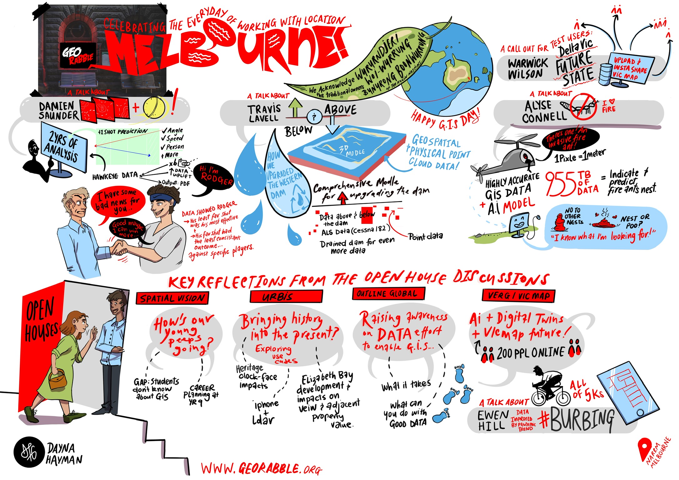
Check out our past speakers’ poster designed by Danya Hayman Design for last year’s Georabble!
Lets keep the ball rolling (or the globe spinning 🌏)! Georabble Newcastle/Hunter is back to celebrate GIS Day on 15 November 2023 from 5:30PM-8PM, hosted at the Happy Wombat on Hunter Street. Secure your tickets here – they’re free!
With the food and venue kindly provided by our sponsor Monteath & Powys, join your local geo-aligned crew for an evening of networking and presentations.
We are seeking EOIs for more speakers at the event. Whether it’s a nifty university project, your own geo-journey, or a work triumph, we are keen to hear from you. If you’re interested, reach out to georabblenewcastle@gmail.com with a short overview of your topic. Remember – keep it short, keep it fun, and no sales pitches please!
We are very excited to announce the countdown to EO Rabble, the same fun, spatial networking event you love, but with a theme around Earth Observation!
Supported and sponsored by the lovely people at the QLD EO Hub
The evening of the 19th October, at the Charming Squire in South Bank – 4 entertaining presentations of success with Earth Observation, lots of networking and a great deal of fun and networking!
Come and enjoy a night out, meet some new people in your industry or catch up with old ones on the night before the GCA QLD conference.
We are on the hunt for guest speakers so please shout out or feel free to nominate someone. Hope to see you there!
GeoRabble on Digital Twins – Revolutionary, Overhyped, or Underwhelming?
GeoRabble Sydney is back on Thursday the 20th of April and we have an exciting theme! It will ask the question … Digital Twins – are they overhyped, underwhelming or revolutionary?
The term Digital Twin has become unavoidable in our professional lives. It is worthwhile to examine what it means for us, for the industry and the broader community.
To get this discussion going join us at the Occidential Hotel Wynard where we will have two knowledgeable and entertaining speakers present their respective views of Digital Twins, so you can make up your own mind!
Andra Christie, Solutions Architect from Amazon and Member of the emerging Digital Twin Partnership has a deep technology skill set that is being focused on the challenges and benefits of digital twins across a broad range of industries.
Ben Somerville, Group Manager – GIS & Geospatial at John Holland. A well know member of the GeoRabble community who daily works with major infrastructure projects across Australia and their need for geospatial data and capabilities.
The speakers will present their views on Digital Twins, followed by a Q&A session. Rabblers will engage in a lively and open discussion with the speakers and afterwards over drinks and pizza.
NGIS: The role of Geospatial in achieving Global Social and Environmental Sustainability Outcomes with Google Earth Engine Following a welcome from the NGIS Team, Ken Gillan, General Manager NGIS Victoria and Geoffrey Pryor, Customer Success Manager for Lively, will introduce the Google partnership and Geo ecosystem. Chris Goodman, Senior Software Engineer, will then provide a demonstration of the Google Cloud Platform including Google Earth Engine and AI/ ML capabilities. Damien O’Grady, Principal Scientist for EO and Peter Corlett, Solution Engineer will then share a few use case examples, before Winyama’s Kelsey Bonds, Community Engagement Manager, will then share details on the Indigenous Mapping Workshop, planned for Melbourne in 2023.
RMIT: Spatial Digital Twins Where in the universe do you find the twins that are digital? Come see a range of digital posters showcasing RMIT’s digital twin related research ranging from data collection, visualisation to decision making, with the highlight being the launch of the RMIT Metaverse.
1. RMIT Metaverse 1.0: linking GIS with gaming 2. iGEE: cloud GIS app for heat vulnerability assessment 3. Satellite positioning and navigation 4. Space and spatial for climate risk and early warning systems 5. A workflow system for environmental modelling 6. Digital twin frameworks – a solution for over-height vehicle routing
Spatial Vision: Spatial Showcase Join the team at Spatial Vision for a double bill on all things spatial. Kicking off with a demonstration of custom tools from Ryanne Firme (DCM Production Manager) on the Digital Cadastre Modernisation project, Rhainnan Mundana (Senior Spatial Geospatial Analyst) will have you planning your next career moves with their presentation on Spatial Vision’s Cadetship and Mentoring Program.
State Library Victoria: Treasures from the Maps Collection National Treasure meets the State Library. Who needs Nicolas Cage when you have Senior Librarian Sarah Ryan? Join Sarah on a curated viewing of selected maps representing the diversity of the State Library Maps Collection.
Please arrive on time, as Sarah our librarian will be meeting us in the foyer. This tour is capped at 20 people but there is the Handmade Universe exhibit which is concurrently on.
SSSI: What is spatial and why is it special? Launching our World GIS Day celebrations is Surveying and Spatial Sciences Institute. Join SSSI as they revel in all things spatial and deep dive into why they think it’s so very special.
SSSI are so pleased to be able to showcase a number of wonderful members at this event, who will be presenting their passion and how they inspire the world with GIS!
Urbis: Shaping cities through spatial Get in shape Melbourne! Danielle Cherubin, Christine Brooks & Josh Grover will be showing us how the spatial team at Urbis helps shapes cities and provide insights through human movement data, and 3D.
Veris: Surveying and GIS Together as One! Come get ‘Verified’ with us. We’re hosting a surveying and spatial circus! Come to the big tent and wherever you find some balloons we’ll be demonstrating our award-winning projects including the Paradise Gorge Digital Twin, the Robe Coastline Capture, the City of Hobart Rivulet Digital Twin, the sightlines for the Shrine of Remembrance and the outputs from our 3D Ground Penetrating Radar! Plus we’ll be demonstrating the latest in our field equipment (that hasn’t been taken out for the day), we have scanners, drones with autonomous LiDAR capture, high-spec MLS and the 3D GPR to name a few! Come tame your spatial lion at the Veris Tent!
GeoRabble speakers:
Oliver Trembearth
Digital twin frameworks – a solution for over-height vehicle routing? The Victorian road freight industry is faced with over-height incidents every year, prompting transportation agencies to seek geospatial solutions. In this talk, we will look at how visualising road objects in a digital twin shows promise as an alternative safety management strategy.
Jack Barrett
Cool Routes Stay Cool in Melbourne this summer. Jack will take you on a journey through the streets of Melbourne to explore the Urban Heat Island effect and how the data captured can be used for future planning considerations of our amazing city.
Danielle Cherubin
Human Movement Data is just so damn interesting! We’ll look at some neat examples of how HMD can be used; not only in a retail setting, but also looking at how nature can have an impact on our movements and behaviour. Let the visuals speak for themselves in what will be a captivating demonstration.
Simon Jackson
Exploring Dial before you dig data
More to be announced soon.
Shout out to our sponsor Nova Systems, we couldn’t host our evening GeoRabble Melbourne event without you!
Why Imagery Data is Really the Best Data, and You Should Use it More
In 1858, Gaspard-Félix Tournachon put a camera in a hot air balloon to take pictures of Paris from the air…and everything has been better since then. In this talk, we will look at how high-resolution imagery from aerial and satellite sources (orthoimagery) is used to support almost every dimension of government and public sector service delivery, and how it is a fundamental enabler for emerging technologies including GeoAI and 3D.
David Pepin
Projecting the frequencies of tidal flooding
Damaging and disruptive, coastal flooding is becoming an increasingly unruly and regular component of coastal living as sea levels rise. With tides on the rise, looking at the issue in new ways can shed light on how we can analyze the issue and communicate to stakeholders.
Oscar So
Anime Pilgrimage – Going beyond Ayaya, Desu, AraAra and Keikaku
‘Geo is in every possible industry’ said everyone in our industry. This is a story of how mapping shaped the Anime Pilgrimage community.
Kelsey Bonds
Growing up Tech Adjacent
Kelsey grew up showing little interest in tech, even though she grew up in a tech household. Her interests are in culture and human connection, something she thought lacked in the tech world. After studying anthropology, she realised just how much tech can and has been utilised to share culture.
Back by popular demand, the next instalment of GeoRabble Brisbane is returning to the Charming Squire
Despite the best attempts of global pandemics and unprecedented weather events, GeoRabble Brisbane is returning to the Charming Squire on the 18th May for another evening of geospatial fun, networking and collective appreciation of some great projects happening locally.
We have an amazing line up of speakers talking about recent flood event and their experiences.
That’s without even mentioning the crowd of friendly spatial professionals to network and make friends with.
So don’t delay, go register now and we will see you upstairs in the Charming Squire on Wednesday 18th.
Tickets available at EventBrite.
A big shout out and thank you to Trimble who have agreed to sponsor the evening.
Speaker lineup
Andy Stewart (State Imagery team, QLD Department of Resources)
The February 2022 SEQ Flooding event was particularly challenging. Andy will share some reflections on getting creative, challenges, adaptations, and future opportunities.
Daniel Knott (Technical Lead, FloodMapp)
Daniel will take us through his and his team’s recent experience in providing support to the flooding events – what it took and what the challenges were.
Mark Grenfell
Geospatial responses to flooding events in Brisbane.
Emma Hain on behalf of Sarah Beardmore (Cofounder, Dorsal)
Northern Rivers floods – harnessing Instagram followers for the ‘Stay local Byron Bay’ campaign to contribute content to a ‘Flood Support Map‘.
Presentations no longer than 10 minutes.
Celebrate each others’ triumphs.
Respect each others’ choice – no technology bigotry.
No sales pitches – this includes services, software, data etc.
It’s finally here! We are excited to have lined up 4 fantastic speakers for tonight’s event and with over 100 registered it’s bound to be a very merry night!
Brett Dascombe: Empowering the next generation of GeoGeeks
Rob Clout: International business travel during a global pandemic
Samantha Garbutt: Engaging a neurodiverse / autistic workforce to help solve our industries skills shortage
Paul Mead: SheMaps – why we need to reimagine STEM
So get yourself a ticket (sadly COVID means no ticket, no getting in) but don’t worry tickets are free and come with a guarantee of no spam or junk, just an invite to a great night out.
Thanks to our fabulous sponsors for the evening, NGIS, without whom this night wouldn’t be possible!
Christmas is almost here, borders are opening, restrictions are easing. So grab your Christmas cheer and join us for some fun and networking!
OK, this is a little last minute, as is often the case at Christmas, but we are all keen to get out and have some fun and network before Xmas holidays, so spread the word far and wide and get as many people as we can down to the usual venue, and leave 2021 in the rear view mirror.
We will be holding the event on Tuesday the 7th December from 5:30ish, with the usual proceedings kicking off at about 6 depending on how distracted our MC gets by catching up with all of you lovely people!
For those who haven’t been lucky enough to attend a Georabble event before, the details are very simple:
Celebrate each others’ triumphs
Respect each others’ choice – no technology bigotry
No sales pitches – this includes services, software, data etc.
No company logos or ‘about us’ slides
Or more simply, its a night of fun, with a little bit of education, but an opportunity to network, meet new friends and catch up with old friends.
So get yourself a ticket, sadly COVID means no ticket, no getting in, but don’t worry tickets are free and come with a guarantee of no spam or junk, just an invite to a great night out.
A big thank you to the very lovely team from NGIS who have agreed to sponsor the evening.
So go get a ticket, tell your friends and we will see you there!
An open and inclusive forum for GeoGeeks to share, inspire and have fun.