
GeoRabble Melbourne Debate
Wednesday 12th of November
Imperial Hotel
6:00pm – 8:00pm
SIGN UP HERE
Come celebrate World GIS day with us (a week early) as our spatial community across the country celebrates.
But we aren’t doing talks and we aren’t at the same venue this year.
We are doing a great debate!
“The Geospatial industry should require a mandatory certification from its professionals”
Come for a night of celebration, a thought provoking debate and gathering with the Melbourne spatial community.
Event Details:  Wednesday, 12th November 2025
 Imperial Hotel, Bourke St
 6:00 PM open, 6:15 PM start!
Expect a fun night of drinks, great company, and good ol’ spatial rabble. Lock in your spot and spread the word!
A big thank you to 1Spatial for sponsoring this event.
If you want to get in touch please contact us via email at georabblemelbourne@gmail.com
Category Archives: Melbourne
GeoRabble Melbourne events

Georabble Melbourne – Seeking Speakers
Hello GeoRabble Community of Melbourne! 🌎
We’re on the lookout for passionate spatial speakers to present at our next Georabble event, which will be held November 20th World GIS Day. Whether you’re working with GIS, remote sensing, cartography, or innovative applications of geospatial technology, we want to hear your insights! Share your research, projects, or unique perspectives to fellow enthusiasts in a causal networking environment.
✨ What We’re Looking For:
– Engaging talks on any thing spatial related!
– Case studies showcasing real-world applications or new innovations in the spatial world.
– Discussions on the impact of geospatial data in various fields (environment, urban planning, disaster management, etc.)
– How unique challenges can be solved with GIS.
💡 Why Share Your Knowledge?
– Inspire and educate fellow members of the geospatial community
– Network with like-minded individuals
– Contribute to the growth and development of geospatial discussions
– Nerd out with fellow spatial geeks!
If you’re interested in speaking or know someone who would be a great fit, please reach out to us at georabblemelbourne@gmail.com!
Lets talk spatial! 🌍
This amazing artwork was done by: Dayna Hayman, www.daynahayman.com.au from our last Georabble! Thank you Dayna!!

Melbourne – Looking for Speakers!
We’re already in the thick of 2024 and gearing up for our next Georabble event on April 18th at the Clyde! 📣We’re looking for dynamic individuals for 10-minute talks. 📣
Interested? Email georabblemelbourne@gmail.com. Stay tuned for the registration link!

Check out our past speakers’ poster designed by Danya Hayman Design for last year’s Georabble!
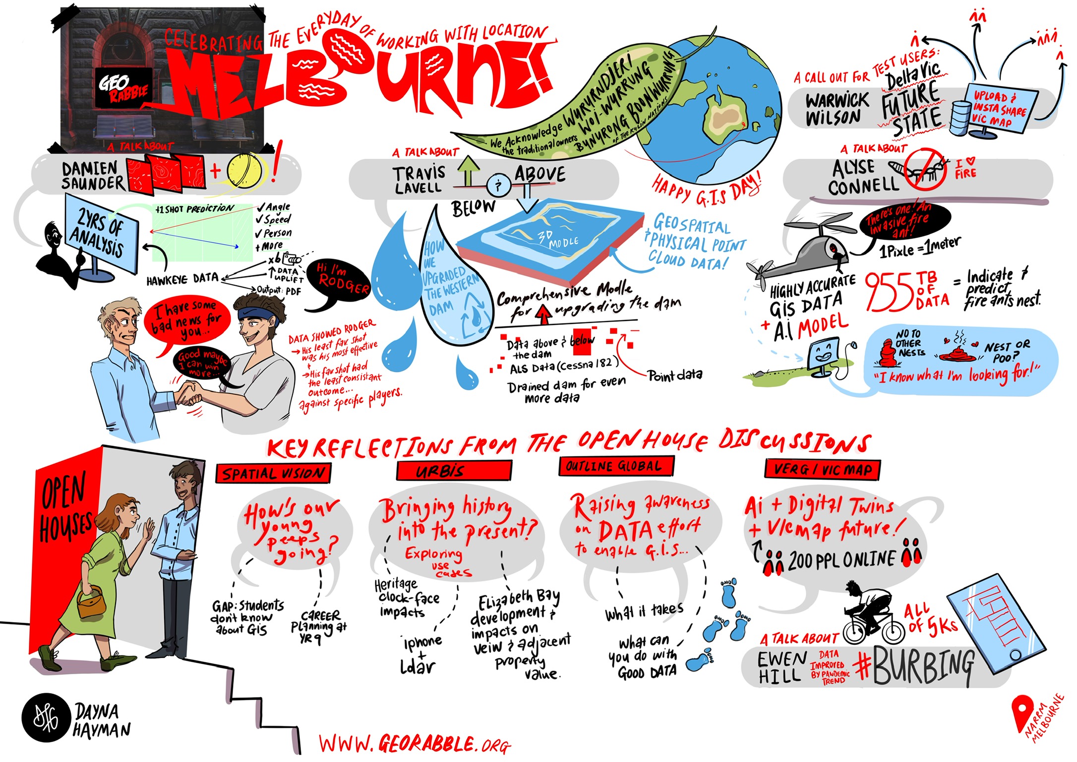
GeoRabble Melbourne – World GIS Day Wednesday 16 November – Be Spatial. Be Special. Tour Melbourne.
World GIS Day: Wednesday 16th November 2022.

What: Open house geo-spatial events / GeoRabble Melbourne
When: Wednesday 16th November 2022 – day and night.
Where: across Melbourne, finishing at The Clyde Hotel 385 Cardigan St, Carlton VIC
Tickets: It is all free!
GeoRabble Melbourne event.
Openhouse venues: Follow the tree to collect a StickyTicket!
| Time | Hosts X | Hosts Y | Hosts Z |
| 11am – 11:45am | What is spatial and why is it special? SSSI (Online & @Veris) | ||
| 11:45am – 12:30pm | Shaping cities through spatial Urbis | Surveying and GIS Together as One! Veris | |
| 1:00pm – 2:00pm | Spatial Showcase Spatial Vision (with lunch catered) | Introducing Nova Systems: Geospatial (formerly Geoplex) Nova Systems (with lunch catered) | The role of Geospatial in achieving Global Social and Environmental Sustainability Outcomes with Google Earth Engine NGIS |
| 2:30pm – 3:30pm | Spatial Digital Twins RMIT | ||
| 4:00pm – 5:00pm | Cultural Heritage, Communities and Digital Infrastructure Engineering University of Melbourne | Treasures from the Maps Collection State Library Victoria | Handmade universe State Library exhibition – |
| 5:30pm – 7:15pm | GeoRabble Melbourne (at the Clyde Hotel, Carlton) |
Open House events:
Nova Systems: Introducing Nova Systems: Geospatial (formerly Geoplex)
The team at Nova Systems is all geo, all the time. Hear from Dani Bramante on Nova Systems Geospatial Overview, Sam Le May on Calculating Bushfire Attack Levels and Joe O’Connell on Plugging in to DTV.
NGIS: The role of Geospatial in achieving Global Social and Environmental Sustainability Outcomes with Google Earth Engine
Following a welcome from the NGIS Team, Ken Gillan, General Manager NGIS Victoria and Geoffrey Pryor, Customer Success Manager for Lively, will introduce the Google partnership and Geo ecosystem. Chris Goodman, Senior Software Engineer, will then provide a demonstration of the Google Cloud Platform including Google Earth Engine and AI/ ML capabilities. Damien O’Grady, Principal Scientist for EO and Peter Corlett, Solution Engineer will then share a few use case examples, before Winyama’s Kelsey Bonds, Community Engagement Manager, will then share details on the Indigenous Mapping Workshop, planned for Melbourne in 2023.
RMIT: Spatial Digital Twins
Where in the universe do you find the twins that are digital? Come see a range of digital posters showcasing RMIT’s digital twin related research ranging from data collection, visualisation to decision making, with the highlight being the launch of the RMIT Metaverse.
1. RMIT Metaverse 1.0: linking GIS with gaming
2. iGEE: cloud GIS app for heat vulnerability assessment
3. Satellite positioning and navigation
4. Space and spatial for climate risk and early warning systems
5. A workflow system for environmental modelling
6. Digital twin frameworks – a solution for over-height vehicle routing
Spatial Vision: Spatial Showcase
Join the team at Spatial Vision for a double bill on all things spatial. Kicking off with a demonstration of custom tools from Ryanne Firme (DCM Production Manager) on the Digital Cadastre Modernisation project, Rhainnan Mundana (Senior Spatial Geospatial Analyst) will have you planning your next career moves with their presentation on Spatial Vision’s Cadetship and Mentoring Program.
State Library Victoria: Treasures from the Maps Collection
National Treasure meets the State Library. Who needs Nicolas Cage when you have Senior Librarian Sarah Ryan? Join Sarah on a curated viewing of selected maps representing the diversity of the State Library Maps Collection.
Please arrive on time, as Sarah our librarian will be meeting us in the foyer. This tour is capped at 20 people but there is the Handmade Universe exhibit which is concurrently on.
SSSI: What is spatial and why is it special?
Launching our World GIS Day celebrations is Surveying and Spatial Sciences Institute. Join SSSI as they revel in all things spatial and deep dive into why they think it’s so very special.
SSSI are so pleased to be able to showcase a number of wonderful members at this event, who will be presenting their passion and how they inspire the world with GIS!
- Rokeya Akter Spatial Analyst, Water Technology
- Brittany Dahl Solution Engineer – Sustainability, NGIS
- David Pullar Senior Lecturer, UQ
- Jasper Wong Geo-Data Graduate, Fugro
University of Melbourne: Cultural Heritage, Communities and Digital Infrastructure Engineering
How do modern digital geospatial technologies affect cultural heritage documentation? How do community dynamics interact in geospatial open source? What on earth is a digital twin? Come and explore these nuanced questions.
Urbis: Shaping cities through spatial
Get in shape Melbourne! Danielle Cherubin, Christine Brooks & Josh Grover will be showing us how the spatial team at Urbis helps shapes cities and provide insights through human movement data, and 3D.
Veris: Surveying and GIS Together as One!
Come get ‘Verified’ with us. We’re hosting a surveying and spatial circus! Come to the big tent and wherever you find some balloons we’ll be demonstrating our award-winning projects including the Paradise Gorge Digital Twin, the Robe Coastline Capture, the City of Hobart Rivulet Digital Twin, the sightlines for the Shrine of Remembrance and the outputs from our 3D Ground Penetrating Radar! Plus we’ll be demonstrating the latest in our field equipment (that hasn’t been taken out for the day), we have scanners, drones with autonomous LiDAR capture, high-spec MLS and the 3D GPR to name a few! Come tame your spatial lion at the Veris Tent!
GeoRabble speakers:
Oliver Trembearth
Digital twin frameworks – a solution for over-height vehicle routing?
The Victorian road freight industry is faced with over-height incidents every year, prompting transportation agencies to seek geospatial solutions. In this talk, we will look at how visualising road objects in a digital twin shows promise as an alternative safety management strategy.
Jack Barrett
Cool Routes
Stay Cool in Melbourne this summer. Jack will take you on a journey through the streets of Melbourne to explore the Urban Heat Island effect and how the data captured can be used for future planning considerations of our amazing city.
Danielle Cherubin
Human Movement Data is just so damn interesting!
We’ll look at some neat examples of how HMD can be used; not only in a retail setting, but also looking at how nature can have an impact on our movements and behaviour. Let the visuals speak for themselves in what will be a captivating demonstration.
Simon Jackson
Exploring Dial before you dig data
More to be announced soon.
Shout out to our sponsor Nova Systems, we couldn’t host our evening GeoRabble Melbourne event without you!
Melbourne GeoRabble

Following our successful GeoRabble back in March 2022, we were keen to bring you another Rabble.
Come along to the Clyde Hotel on Cardigan Street and listen to our exciting speakers. Grab a drink and a bite to eat and relax.
Speaker details are below, but if you want to speak at this GeoRabble or the next please get in touch.
We have NGIS onboard for this GeoRabble, massive thanks!
As always we are keen to hold another Rabble and if we can before the year is out, so if you are interested in being a sponsor, please get in touch.
Date: Thursday 18th August 5:30pm – 8pm
Location: 385 Cardigan St, Carlton VIC
https://www.theclydehotel.com.au/
Tickets: It is free, but to help us with registrations, please do grab a ticket.
https://www.eventbrite.com.au/e/melbourne-georabble-tickets-390979067917
Speakers:
Alena Moison
Why Imagery Data is Really the Best Data, and You Should Use it More
In 1858, Gaspard-Félix Tournachon put a camera in a hot air balloon to take pictures of Paris from the air…and everything has been better since then. In this talk, we will look at how high-resolution imagery from aerial and satellite sources (orthoimagery) is used to support almost every dimension of government and public sector service delivery, and how it is a fundamental enabler for emerging technologies including GeoAI and 3D.
David Pepin
Projecting the frequencies of tidal flooding
Damaging and disruptive, coastal flooding is becoming an increasingly unruly and regular component of coastal living as sea levels rise. With tides on the rise, looking at the issue in new ways can shed light on how we can analyze the issue and communicate to stakeholders.
Oscar So
Anime Pilgrimage – Going beyond Ayaya, Desu, AraAra and Keikaku
‘Geo is in every possible industry’ said everyone in our industry. This is a story of how mapping shaped the Anime Pilgrimage community.
Kelsey Bonds
Growing up Tech Adjacent
Kelsey grew up showing little interest in tech, even though she grew up in a tech household. Her interests are in culture and human connection, something she thought lacked in the tech world. After studying anthropology, she realised just how much tech can and has been utilised to share culture.
Suelynn Choy
Beep Beep
The power of GPS and GNSS.
Thanks to our sponsor NGIS!

GeoRabble Melbourne Thursday 12 March 2020
Come one come all, its time to bring the rabble together for another Melbourne GeoRabble.
GeoRabble returns to Melbourne on Thursday 12 March 2020 at Cooper Inn on the corner of Little Lonsdale and Exhibition Street. Networking drinks start at 5:30pm. Presentations commence shortly there after followed by more networking.
Tickets are available online– note space is limited – enjoy the night with friends sharing geospatial ideas, free of sales pitches and hidden agendas! Each presentation is light, relevant to geo-something and only 10 minutes long.
https://www.eventbrite.com.au/e/georabble-melbourne-tickets-94097705771
Speakers
Leila H.Mirkalaei – Integration of cadastral survey information into BIM
Along with the growth in 3D cadastre, lack of survey information and 2D observations have existed with the current BIM applications. During the 3D building formation procedure, the survey information and 2D observations are only used for cadastral registration and have not been included in BIM.
Sylvia Niderla – The Joys of Mentoring in a Sh*tty World
My experiences with mentoring a GIS Graduate in the SSSI mentoring program 2018 – experiences and lessons learnt.
Dr Jon Stanger – MAGNM – A novel approach to validating and managing networked assets.
Multiple highly interconnected networks (infrastructure, cabling, logical, bearer) can be modelled using classical graphs (mathematical structures that model pairwise object relationships) with Multi-axis Graph Network Model (MAGNM) representation utilizing open source GIS libraries and software.
Mina Jahanshahi – 99 Bluetooth Ballons
If an artist can take a little red cart of phones around Berlin to hack a Google traffic jam, who else or what else will be disrupting our data sources in the future? While we’re hacking away at making our own data, who else is counter-hacking it? How much are we relying on non-standard data sources for our inputs and where should we be trying to find data governance? Interactive talk- for every buzzword I use I ask you to heckle me with a hiss.
Natalie Scott: Lights and Sirens: Building a network for fire appliances
We use networks to answers questions about how long it takes to get somewhere, or how far we can go within a set time. While we are accustomed to being able to answer these questions for cars, how do you go about building a suitable network for a fire appliance? I’ll be talking about some of the different approaches we’ve used, and why it matters.
More speakers to be announced soon.
If you have a great geospatial idea that you would like to share with a group of like-minded people, we want to hear from you for the next GeoRabble! Contact the GeoRabble committee to express your interesting topic in 20 words or less, or email your idea to melbourne@georabble.org.
We would like to thank our sponsor LandSurveys without which we could not hold this event. Thanks!
![]()
GeoRabble Melbourne Thursday 17 October
GeoRabble returns to Melbourne on Thursday 17 October 2019 at the Imperial on Bourke Street. Networking drinks start at 5:30pm. Presentations commence shortly there after followed by more networking.
Grab yourself a ticket and enjoy the night with friends sharing geospatial ideas, free of sales pitches and hidden agendas! Each presentation is light, relevant to geo-something and only 10 minutes long.
https://www.eventbrite.com.au/e/georabble-melbourne-tickets-73093758399
Speakers
Sylvia Niderla – My job was boring so I automated it (in FME)
Using FME to automate repetitive/manual tasks, replace lengthy scripts and extract CAD files (DGN) to a web mapping application.
Ayeisha Sheldon – My journey as a young Women in Geospatial science
Ayeisha will highlight key projects she has worked on, lessons learnt and experience gained. These projects include, mapping for disaster reduction within the Asia Pacific and projects while working for the Space Applications Section at the United Nations ESCAP.
Dayna Hayman – The power of visualisation
Coming from a visual design background, Dayna has a great appreciation for the ways in which good visualisations are an indispensable tool to help teams understand content and reflect on their experiences. In this talk, Dayna will discuss how she has used graphic live-scribing in highly technical workshops, and the unique value that it has delivered in these contexts.
Kate Williams – Fishermans Bend Digital Twin Demonstrator Project
Victoria’s first digital twin project for urban planning will demonstrate the digital future of our cities through the application of state-of-the-art planning and mapping technology to visualise Fishermans Bend, Australia’s largest urban renewal project, covering 485 hectares in the heart of Melbourne and soon to be home and workplace for over 80,000 people. Kate will share the scope of the demonstrator project, and discuss key learnings from the first 4 months of this initiative.
If you have a great geospatial idea that you would like to share with a group of like-minded people, we want you for our next GeoRabble! Contact the GeoRabble committee to express your interesting topic in 20 words or less, or email your idea to melbourne@georabble.org.
We would like to thank our sponsor ThinkPlace without which we could not hold this event.
![]()
Georabble Melbourne #10 | 23 Nov
GeoRabble returns to Melbourne on Thursday 23rd November 2017 at the Imperial Hotel, 2 Bourke St, Melbourne (Corner Bourke & Spring Sts). Networking drinks start 5:30pm. Presentations commence: 6:00pm followed by more networking.
Grab yourself a free ticket and enjoy the night with friends sharing geospatial ideas, free of sales pitches and hidden agendas! Each presentation is light, relevant to geo-something and only 10minutes long.
Speakers:
Melinda Clarke – Putting Melbourne on the Map – Experiences of illustrated map making from the first edition of the Melbourne Map, published 1990, and the second, due early next year.
Anton Thomas – Drawing a continent by hand – a search for harmony between the creative freedoms of art and the geographic truth of cartography
Alex Webster – Unlocking 3D opportunities – Cost effective ways to access VR and develop an organisation awareness.
Tom Hollands – Data obfuscation in China – The art of confusing travellers and keeping data private.
Verity Miles – How is Dwelling density shaping our city? – A look at Melbourne’s dwelling density from a number of different angles.
Adam Mattinson (@mappinson) Mapping alternate universes and geofictionalised versions of Melbourne.
Rescheduled for a future event:
Simon O’Keefe – Government web services – A look into WMS/WFS (Web Mapping Services / Web Feature Services)
More speakers to follow…
If you have a great geo-spatial idea that you would like to share with a group of like minded people, we want you! Contact the GeoRabble committee asap to express your interesting topic in 20words or less, or email your idea to melbourne@georabble.org
A very special thanks to our Sponsor Spatial Vision without whom we couldn’t run this event and provide food to everyone …

Georabble Melbourne #9 Announced
GeoRabble returns to Melbourne on Tuesday 15th March 2016 at the Savoy Tavern, 677 Bourke St, Melbourne (Corner Bourke & Spencer Sts). Networking drinks start 5:30pm. Presentations commence: 6:00pm followed by more networking.
Grab yourself a free ticket and enjoy the night with friends sharing geospatial ideas, free of sales pitches and hidden agendas! Each presentation is light, relevant to geo-something and only 10minutes long.

Speakers:
Anton van Wyk – Psychology of UAV Pilot
Bernhard Jenny – Scale Adaptive Web Projections
Henry Walshaw – Creating a QGIS plugin in 10 mins!
Warwick Wilson – DELWP Spatial Metadata
Mohsen Kalantari – Automatic reconstruction of 3d indoor models
More to be announced soon!
If you have a great geo-spatial idea that you would like to share with a group of like minded people, we want you! Contact the GeoRabble committee asap to express your interesting topic in 20words or less, or email your idea to melbourne@georabble.org
A very special thanks to our Sponsor Hexagon Geospatial – Ignite Competition without whom we couldn’t run this event and provide food to everyone …

GeoRabble Melbourne # 7 has been announced!
GeoRabble returns to Melbourne on Thursday 25th June 2015 at the Royal Melbourne Hotel, 629 Bourke St, Melbourne. Networking drinks 5:30pm. Presentations commence: 6:00pm followed by more networking.
Grab yourself a free ticket and enjoy the night with friends sharing geospatial ideas, free of sales pitches and hidden agendas! Each presentation is light, relevant to geo-something and only 10minutes long.
Registrations now open go to Eventbrite to grab your ticket!
We are calling for guest speakers – if you have a spatial idea that you would like to share with a group of like minded people, we want you! Contact the GeoRabble committee asap to express your interesting topic in 20 words or less, or email your idea to melbourne@georabble.org
We will announce our speaker list soon
A very special thanks to our GeoAwesome sponsor Address Exchange without whom we couldn’t run this event and provide food to everyone.

